
Beacons View, near Monmouth
Walk through heathland and woodland
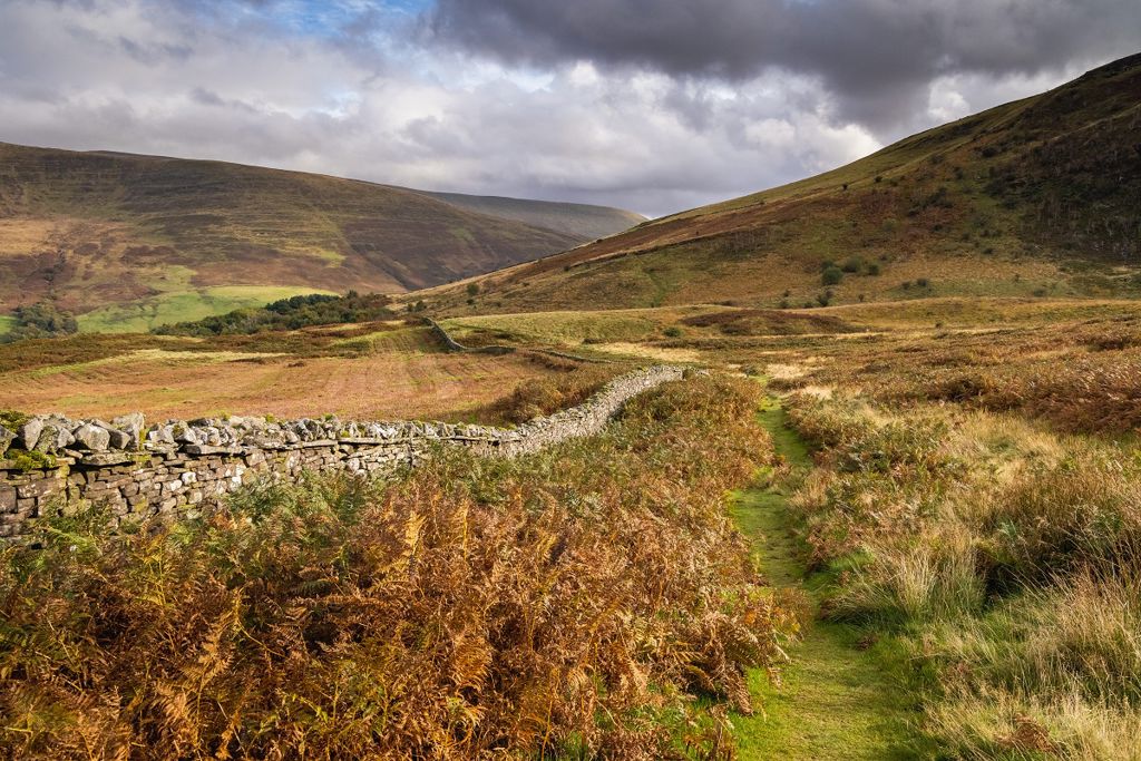
Experience a craggy mountain landscape just a few hundred metres from the A470 in the Bannau Brycheiniog National Park.
Here you will find yourself enclosed within an atmospheric amphitheatre created by the soaring cliffs of Craig Cerrig Gleisiad.
Try our waymarked walks to get a flavour of the reserve or, for map-readers wanting a longer walk, footpaths lead upwards to the lofty, exposed moorlands of Fan Frynych and across to the spectacular cliffs at Craig Cwm-du.
There is a small picnic site next to the reserve entrance.
The Bannau Brycheiniog National Park Visitor Centre is a short drive away.
The walking trails are waymarked from start to finish.
Look out for the information panel at the start of the trails.
Find out about walking trail grades.
Experience the majestic landscape on this walk along the river to the base of the rocky slopes of Craig Cerrig Gleisiad.

You get a great feel for the craggy heights of Craig Cerrig Gleisiad from both near and far on this circular route.
It sets off alongside the river and climbs steeply through heather and bilberry to a cairn.
There are great views towards Pen y Fan on the return.

There are footpaths leading upwards to the plateau of Fan Frynych and across to Craig Cwm-du.
These may not be signposted and we recommend that you take a map with you.
The Beacons Way goes along the southern edge of the reserve’s boundary.
This 99 mile (159 kilometre) long-distance route crosses remote and rugged terrain.
It has limited waymarking but the route is shown on the Ordnance Survey (OS) map or you can get a route guide from the Bannau Brycheiniog National Park's online shop.
You can join the Beacons Way on a footpath from the lay-by at the reserve entrance.
For more information about the Beacons Way go to the National Park's visitor website.
Craig Cerrig Gleisiad a Fan Frynych is a National Nature Reserve.
National Nature Reserves are places with some of the very finest examples of wildlife habitats and geological features.
The landscape and wildlife varies depending on which time of year you visit – here’s what to look out for.
A glacier carved out this valley during the last ice age.
As it melted, about 18,000 years ago, it exposed the steep rock walls of Craig Cerrig Gleisiad.
Some time later, a catastrophic landslide cascaded millions of tonnes of rock from these crags down the slopes.
Archaeological remains found on the reserve show that the area has been inhabited for many thousands of years.
Apart from Iron Age huts there are also the remains of a Roman road and later farm settlements.
The steep rocky slopes, sharp escarpments and crags are home to rare arctic-alpine plants. These are at their southernmost location in the UK and are not found again until the Alps.
Arctic-alpine wildflowers grow on the north-facing rocky cliffs. They include purple saxifrage, mossy saxifrage, serrated wintergreen and green spleenwort.
The cliffs are, in effect, a vertical woodland with trees and shrubs of hawthorn, rowan, ash and rare whitebeams.
There is a also rich variety of wildflowers and many different mosses and liverworts.
Early spring to mid-summer is a great time to see the reserve’s spectacular range of wildflowers and also its birdlife including peregrines, kestrels, red grouse and rare ring ouzels.
In August and September the hillsides come alive with the glow of heather.
There are over 70 National Nature Reserves in Wales.
Find out more about National Nature Reserves.
Craig Cerrig Gleisiad Nature Reserve is in the Bannau Brycheiniog National Park.
The National Park covers approximately 520 square miles of mountains and moorland in South and Mid Wales.
It is looked after by the Bannau Brycheiniog National Park Authority.
For more information go to the National Park's visitor website.
We want you to return home safely after your visit here.
You are responsible for your own safety as well as the safety of any children and animals with you during your visit.
Please note:
For advice and tips to help you plan your visit here go to Visiting our places safely.
See the top of this webpage for details of any planned closures or other changes to visitor facilities here.
For your safety, always follow instructions from staff and signs including those for trail diversions or closures.
We may divert or close trails whilst we undertake maintenance work or other operations and we may need to close other visitor facilities temporarily.
In extreme weather, we may close facilities at short notice due to the risk of injury to visitors and staff.
You may need permission from us to organise an event or to carry out some activities on our land.
Check if you are allowed to use our land.
We recommend you follow these directions or use the Google map below which has a pin on this place’s location.
Craig Cerrig Gleisiad a Fan Frynych National Nature Reserve is 6½ miles south of Brecon.
From Brecon follow the A470 towards Merthyr Tydfil.
After approximately 5 miles, go past the entrance to a youth hostel on the left.
Turn into the second lay-by on the right, about 500 metres after the entrance to the youth hostel – look out for the information panel just beyond the gate at the reserve entrance.
The Ordnance Survey (OS) grid reference for the lay-by adjacent to the entrance to the reserve is SN 971 222 (Explorer Map OL 12).
The postcode is LD3 8SU. Please note that this postcode covers a wide area and will not take you directly to the entrance.
View this place on the What3Words website.
The nearest mainline railway station is in Aberdare.
There is a bus stop at the entrance road to the YHA Brecon Beacons on the A470. This bus top is around 500 metres from the reserve entrance – please take care walking from the bus stop to the reserve entrance.
For details of public transport go to the Traveline Cymru website.
There is parking in the large lay-by on the A470 adjacent to the entrance to the reserve - look out for the reserve sign just behind the gate.
There are no staff at this location.
Contact our customer team for general enquiries during office hours, Monday to Friday.


