
Afan Forest Park – Visitor Centre, near Port Talbot
Main starting point for mountain bike and walking...
The landscape at Coed Tŷ Canol National Nature Reserve features gnarled and twisted oaks, rock outcrops, old stone walls and an Iron Age fort.
It is one of the richest sites for lichens anywhere in Britain and Ireland – these adorn the boulders and trees and are the main reason for the woodland’s status as a National Nature Reserve.
The woodland is a mixture of ancient oak woodland and wood pasture which has been grazed by cattle, sheep and ponies for many centuries.
Follow our walking trail through the reserve to see the ancient woodland’s oak trees and the mystical landscape, and enjoy the display of bluebells in spring.
The walking trail is waymarked from start to finish.
Look out for the information panel at the start of the trail.
Find out about walking trail grades.
Get a real feel for Coed Tŷ Canol on our walk through this enchanting reserve.
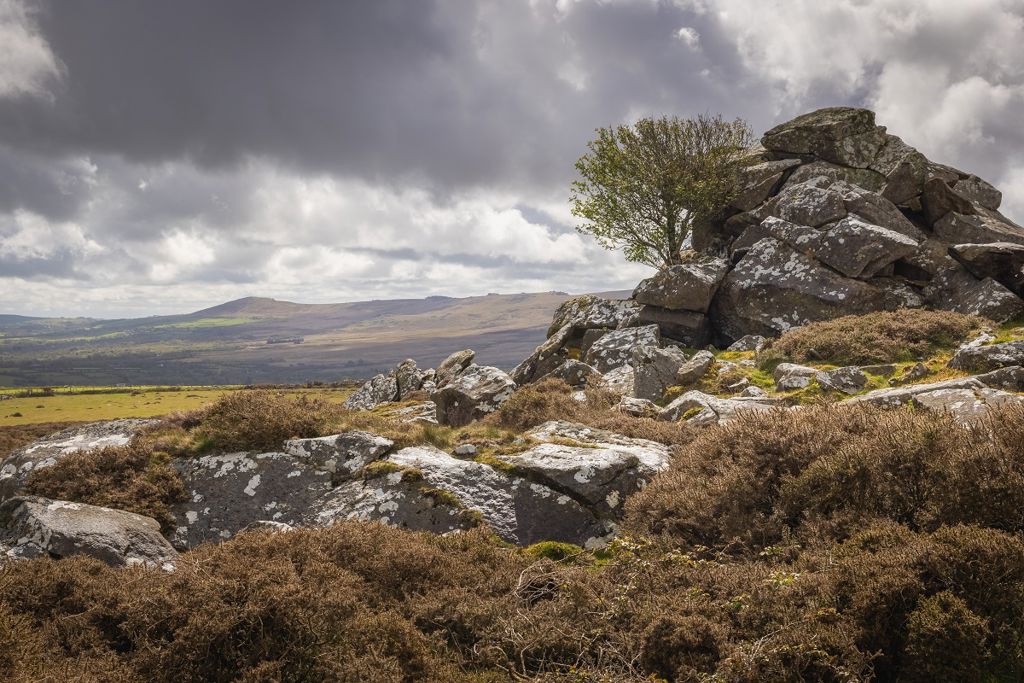
See the ancient oak trees and the rocky outcrops of Carnedd Meibion Owen, and enjoy the panoramic views of Pembrokeshire.

There are public footpaths to Coed Tŷ Canol from the nearby Urdd Gobaith Cymru Centre.
You can also walk to the Pentre Ifan burial chamber from the reserve.
Coed Tŷ Canol is a National Nature Reserve.
National Nature Reserves are places with some of the very finest examples of wildlife habitats and geological features.
The landscape and wildlife varies depending on which time of year you visit – here’s what to look out for.
Woodland cover has ebbed and flowed here since the Ice Age and the woodland was already old when the Pentre Ifan stone burial chamber was built nearby 5500 years ago.
The steeply sloping woodland at Coed Tŷ Canol seems like a typical Welsh upland oakwood, where sessile oak is the dominant tree with scattered birch, mountain ash and hazel. But this woodland has a long history of agricultural grazing – resulting in a more open type of woodland called wood pasture.
The northern and lowest part of the reserve, Hagr y Coed (‘hagr’ means ‘ugly’ in Welsh), is wet woodland, with numerous small spring-fed streams and some long abandoned fields within it. Oak is the main tree here with some ash and downy birch.
If you walk through the reserve you will see that many of the surfaces of the rock faces, tree trunks and branches are covered in lichens.
Lichens need light and the growth of woodland plants which would usually shade them out has been kept in check here by the long history of grazing, allowing them to flourish.
Nowadays we continue to use grazing animals and remove selected oak trees to look after the lichens.
There are over 70 National Nature Reserves in Wales.
Find out more about National Nature Reserves.
Coed Tŷ Canol National Nature Reserve is in the Pembrokeshire Coast National Park.
The Pembrokeshire Coast is Britain's only truly coastal National Park, covering 240 square miles of spectacular landscape around Wales's south-western shore.
It is looked after by the Pembrokeshire Coast National Park Authority.
For more information about visiting the National Park go to the Pembrokeshire Coast National Park website.
We want you to return home safely after your visit here.
You are responsible for your own safety as well as the safety of any children and animals with you during your visit.
Please note:
For advice and tips to help you plan your visit here go to Visiting our places safely.
See the top of this webpage for details of any planned closures or other changes to visitor facilities here.
For your safety, always follow instructions from staff and signs including those for trail diversions or closures.
We may divert or close trails whilst we undertake maintenance work or other operations and we may need to close other visitor facilities temporarily.
In extreme weather, we may close facilities at short notice due to the risk of injury to visitors and staff.
You may need permission from us to organise an event or to carry out some activities on our land.
Check if you are allowed to use our land.
We recommend you follow these directions or use the Google map below which has a pin on this place’s location.
Coed Tŷ Canol National Nature Reserve is 4½ miles south east of Newport, Pembrokeshire.
From the A487 through Newport take the minor road signposted towards Cilgwyn.
After 2¼ miles, turn left at the T-junction towards Maenclochog.
After ½ mile, turn right at the T-junction.
After another ½ mile, turn left back on yourself, signposted Brynberian.
As the road bends right, the informal parking area is in a lay-by just off the road.
The Ordnance Survey (OS) grid reference for the parking area is SN 092 359 (Explorer Map OL 35).
The postcode is SA42 0QP. Please note that this postcode covers a wide area and will not take you directly to the entrance.
View this place on the What3Words website.
The nearest mainline railway station is in Goodwick.
For details of public transport go to the Traveline Cymru website.
Parking is in a lay-by to the south of the reserve.
Parking is free of charge.
There are no staff at this location.
Contact our customer team for general enquiries during office hours, Monday to Friday.


